
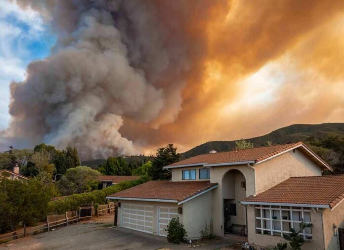
The security-camera view of a wildfire racing toward a home near Madrid is not an outlier freak event; it is a brutally clear illustration of how fast modern fires are now intersecting with everyday residential life in Spain’s capital region.
Key Points
- Wildfires in the Madrid region have repeatedly pushed into or up to the edges of housing developments, forcing large-scale evacuations and, in some cases, destroying homes.
- The viral security-camera clip of flames racing toward a house fits a wider pattern documented by drone, aerial, and ground footage from Spanish authorities and broadcasters.
- Evacuations in communities south and west of Madrid, particularly in Villa del Prado, San Martín de Valdeiglesias, and nearby towns, reflect a structural shift: the wildland-urban interface around the capital is now a recurrent fire front.
- Highly compressed social-video clips powerfully convey fire behavior but strip away metadata, making independent verification of exact location, timing, and provenance a separate, often incomplete, task.
When wildfire meets the front door: what the Madrid footage shows
The starting point is straightforward: major wildfires have burned close enough to metropolitan Madrid in recent years that homes, vehicles, and entire housing estates have been damaged or destroyed, and tens of thousands of residents have been ordered to evacuate. In that context, a security camera capturing flames racing across a plot and engulfing a house within minutes is not an abstract metaphor; it is a literal record of the kind of run these fires can make once they align with wind, slope, and dry fuels.
Local Spanish coverage has described security-camera footage from Navas del Rey, in the Sierra Oeste corridor west of Madrid, showing flames crossing the property and consuming a house in around eight minutes, underscoring just how narrow the window for safe evacuation can be. That same corridor—Pelayos de la Presa, San Martín de Valdeiglesias, Chapinería, and neighboring municipalities—features repeatedly in emergency reports and aerial images of the region’s worst wildfires, with homes, swimming pools, and garden plots clearly visible in the foreground of the fire front.
The Madrid wildfire emergency in context
To understand the stakes of a single camera angle, you have to place it inside the broader Madrid wildfire sequence. In multiple seasons, large fires have broken out both north and west of the capital, sometimes within 20–25 kilometers of the city limits. Tres Cantos to the north, Cebreros and Navaluenga to the west, and urbanisations such as El Encinar del Alberche or Soto de Viñuelas have all found themselves suddenly on or near an active fire perimeter.
In one widely reported episode, authorities in the Community of Madrid and neighboring provinces ordered evacuations or lockdowns affecting on the order of 60,000 residents west of the capital, as multiple fires—fanned by heat and wind—burned through scrub, pine, and agricultural land. Euronews and other outlets reported Spanish Civil Guard officers going door to door in Villa del Prado and adjacent communities near Toledo, urging people to leave as thick smoke and flames closed in on residential streets. In parallel, European broadcasters carried aerial footage showing isolated houses and clusters of homes engulfed by flames in the Sierra Oeste area, confirming that the fires did reach built structures rather than remaining a distant forest problem.
From drone panoramas to doorbell cameras: a layered visual record
The security-camera clip that has circulated on social media is one layer in a multi-source visual record of these Madrid-region fires. Government and emergency services in Spain have released drone and helicopter footage that show broad fire fronts moving through the landscape, sometimes with intricate detail: thermal imagery outlining the hottest edges, and wide shots revealing how close the flames are to roads, powerlines, and housing clusters. One government drone sequence from Almorox, in the neighboring province of Toledo, captures fire progression towards the type of peri-urban zones where detached homes, small farms, and forest edges interlace.
News agencies and photo archives complement those official feeds with their own aerial and ground video. Aerial views distributed via international outlets and stock agencies depict homes burning or already destroyed in areas west of Madrid, often with fire crews concentrating on saving remaining structures and critical infrastructure. Ground-based clips—shot by firefighters, residents, or local journalists—show walls of flame overtaking tree lines, embers swirling in high winds, and convoys of cars leaving smoky villages at night.
Within that mosaic, the security or doorbell camera occupies a very different vantage point: fixed, low to the ground, and focused on a single property line. It does not explain the origin of the fire, overall meteorology, or suppression strategy, but it does something else almost no other angle does as clearly: it makes the fire’s arrival legible at human scale. You can see how far away it appears at minute zero, what the smoke looks like when the first embers land, and how quickly visibility and survivable conditions collapse once the front reaches the fence line.
How fast fires move in the wildland‑urban interface
The speed apparent in the Madrid security-camera footage is not an illusion of fast-forward editing; it tracks with what fire behavior analysts expect when wind, slope, and cured fine fuels line up. In Mediterranean ecosystems—the oak and pine woodlands, scrub, and agricultural fringe common around Madrid—fine fuels such as dry grass, leaf litter, and low shrubs dominate the initial spread. When these fuels are critically dry and the wind is aligned, flame fronts can advance hundreds of meters in minutes, especially upslope.
Reports from Madrid-region fires describe fire behavior that is entirely consistent with what the camera shows. In some documented incidents, new blazes started around dusk, and within less than an hour had advanced toward the outskirts of commuter towns or housing complexes, forcing emergency evacuations before midnight. Firefighters have described fires “running” through scrub and open fields, jumping roads and irrigation ditches when pushed by gusty, unstable winds. The bulk of the energy may reside in forested canyons or ridgelines, but the dangerous reach for homes often occurs through those fast-moving, lower-intensity grass and shrub runs that deliver embers and radiant heat to patios, vehicles, and eaves.
In such conditions, the traditional mental model of a distant forest fire slowly approaching a community over a day or two no longer holds. Instead, many residents around Madrid encountered a dynamic more familiar from California, Greece, or Portugal: a fire starting in seemingly modest fuels some distance away that, within a single operational period, is throwing embers into their streets.
Evacuation on the clock: what authorities actually did
The footage of flames closing in naturally raises a question: were residents warned and evacuated in time? Here, the documentary record is stronger than it sometimes is in fast-moving disasters. Across several Madrid-region fire episodes, civil-protection authorities, the Civil Guard, and local police have used a combination of door-to-door evacuations, loudspeaker announcements, and broadcast alerts to clear threatened neighborhoods.
In Villa del Prado and nearby communities south of Madrid, for example, Euronews video shows officers entering homes, assisting older residents, and checking that properties were empty as thick smoke obscured the sky. In other cases, residents were ordered to shelter in place—closing doors, windows, and air conditioning—to avoid smoke exposure when immediate evacuation routes were compromised. At the regional level, Spanish and regional officials declared escalating emergency levels, ultimately moving to a national emergency status when it became clear that Madrid’s fires were part of a much larger, cross-border wildfire crisis.
This operational backdrop matters because it clarifies that the security-camera clip is not depicting an ignored or unexpected hazard; it is documenting the closing minutes of a risk that emergency services were trying, at scale, to stay ahead of. Whether every household received optimal warning is a separate, incident-by-incident question, but the pattern of mass evacuations and temporary confinement orders is clear in the record.
Verification, provenance, and the limits of viral video
While the underlying reality of Madrid-region wildfires is extensively documented, the specific security-camera clip that has ricocheted around social platforms illustrates a recurring verification problem. Most viewers encounter it after multiple rounds of reposting, stripped of original filenames, timestamps, or even consistent location captions. By the time it appears as a short, looping video in feeds, crucial provenance details—exact address, precise date, original owner—are often absent.
Professional verification work typically relies on three kinds of evidence that the social copies do not provide by themselves. First, the original file and metadata, ideally obtained from the homeowner, their insurer, or investigators, can confirm creation time and device details. Second, frame-by-frame geolocation—matching terrain, vegetation, building features, and views of distant ridgelines to satellite and street-level imagery—can anchor the camera to a specific plot. Third, cross-referencing with official incident logs, perimeter maps, and damage assessments can tie the observed fire run to a particular operational period of a known wildfire.
In the Madrid case, secondary reporting clearly anchors similar security-camera imagery to Navas del Rey and other named communities in the Sierra Oeste fire zone, and it aligns the run time—on the order of 7–8 minutes between first visible approach and structural involvement—with what local officials and eyewitnesses have described. What remains less visible in the public domain is the full chain of custody for the widely shared clip itself. This gap does not undermine the basic factual conclusion that wildfires near Madrid have rapidly overrun residential properties; that conclusion is independently supported by drone footage, aerial imagery, official statements, and ground reports. It simply reminds us that any individual viral clip sits within a larger evidentiary ecosystem that must be considered when making fine-grained claims about location and timing.
Why this matters beyond Madrid
For residents in and around Madrid, the lessons are immediate and concrete: defensible space around homes, clear evacuation routes, and close attention to civil-protection messaging are now part of living in what has become a fire-influenced landscape. For a wider audience, the security-camera clip is a visceral education in how quickly conditions can deteriorate once a wildfire breaks into the wildland‑urban interface. It compresses into a few minutes what policy reports and risk maps have been urging for years: the line between “forest fire” and “urban disaster” is thinner than it used to be, especially during compound heat, drought, and wind events.
It also underscores a broader shift in how we come to know disasters. In earlier eras, our main visual references were newsreels and professional photojournalism, filtered through editorial processes that, for all their imperfections, placed a premium on clear attribution. Today, a significant share of the most influential imagery originates from consumer devices—security cameras, smartphones, drones—whose files are immediately atomized and redistributed across platforms. That change has democratized documentation but also complicated verification. The Madrid wildfire footage, both official and amateur, shows the best and worst of that new reality: coverage that is richer and more immediate than ever, and yet, in some of its most gripping fragments, detached from its own paper trail.
Security camera footage capture a wildfire racing toward a home near Madrid raging wildfires 🔥 have forced more than 300,000 people to flee pic.twitter.com/z0CycbiWhV
— Franko (@Franko52808) July 26, 2026
Living with fire at the edge of a capital city
Madrid is not a frontier outpost; it is a major European capital whose commuter belts, weekend villages, and exurban estates now sit, quite literally, on the fire line. The security-camera view of flames racing toward a home is therefore not only a Spanish story. It is a preview of the kind of risk that many metropolitan regions with encroaching development and fire-prone landscapes are likely to see more often. Understanding what happened in those eight or so minutes on a single property plot requires, and rewards, looking at the larger system: the climate and fuel conditions that built the fire, the emergency machinery that tried to keep pace with it, and the media ecosystem that turned a private surveillance device into one of the defining images of an era of urban-adjacent wildfire.
Sources:
facebook.com, ru.euronews.com, parsi.euronews.com, youtube.com, euronews.com, bbc.com, eldebate.com, shutterstock.com, spectee.com, gettyimages.co.uk, thespanisheye.com, dailymotion.com, aljazeera.com