

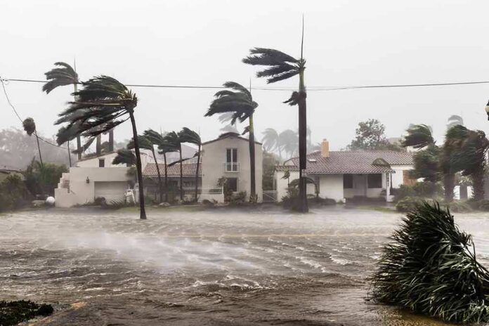
In Gulf Coast storms, water and wires do the most damage; Edouard proved it again, drenching east and southeast Texas, flooding roads, and cutting electricity to tens of thousands as the system tracked inland.
At a Glance
- Edouard made landfall near the Texas–Louisiana border and moved northwest into Texas, with heavy rain and flash flooding across the Upper Texas Coast into east-central Texas.
- Forecasts called for 3 to 7 inches of rain with local maxima near 12 inches; tornadoes were possible in southeast Texas and southwest Louisiana.
- Power outages climbed into the tens of thousands around Jefferson County and across southeast Texas as trees and lines went down in squalls.
- The inland flood threat outlasted coastal wind; advisories emphasized continued heavy rain and flash flooding even as the storm weakened over land.
What Edouard did: inland flooding, outages, and localized wind damage
Edouard came ashore near the Texas–Louisiana line and then pressed inland over southeastern Texas. As the circulation moved across Jefferson County, reporters and local broadcasters documented flooded roadways, downed trees, and widespread power interruptions. In Beaumont and the Port Arthur area, outage counts reached into the tens of thousands as peak wind bursts and saturated soils combined to topple limbs into distribution lines. Region-wide, outages rose across the evening, crossing 80,000 affected customers as the storm’s wet core marched northwest and rain bands pivoted repeatedly over the same communities.
The core dynamic was never mysterious: Edouard’s moisture fields were deep, steering winds were slow, and the frictional lift over land wrung out prolonged downpours on the storm’s left flank. That is exactly the profile that turns a marginal wind event into a consequential hydrologic one. The National Hurricane Center (NHC) advisories set expectations clearly ahead of time—3 to 7 inches common, locally up to 12 inches from the Upper Texas Coast into east-central Texas—with flash flooding likely and significant flash flooding possible. River flooding was also on the table, contingent on where the heaviest training bands stalled.
How the hazard evolved: classification vs. impact
Labels changed as Edouard crossed the coast and began to spin down, but the impact story did not. NHC bulletins during the day referenced Tropical Storm Edouard; by late evening, advisories reflected a weakening tropical depression over land. The label shift is meteorological bookkeeping—sustained winds easing below tropical-storm threshold as surface friction and dry intrusions eroded the core—not a downgrade of risk. The flood threat typically peaks after landfall for Gulf systems that move slowly and tap warm, moisture-rich air. NHC discussions underscored that point, warning that heavy rain and flash flooding would persist into Thursday morning across the Upper Texas Coast, east-central Texas, and into far southwest Louisiana even as the circulation weakened.
Local statements from the National Weather Service office in Houston/Galveston tracked the center inland and warned of scattered power and communications outages along its path. The office highlighted a continued northwest motion across East and Southeast Texas—a trajectory that naturally focused the heaviest rain from Jefferson and Orange Counties into Liberty, Polk, and points north and west, with sharp local gradients such that one township faced submerged low-water crossings while another, just 25 miles away, saw manageable ponding and breezy showers.
Rain, wind, and the outage mechanics
For seasoned Gulf observers, the mechanics were familiar. Wind gusts in the 50–70 mph range—measured and reported around Sabine Pass and the Port Arthur area during landfall television coverage—are enough to shred weaker branches and shift shallow-rooted trees in saturated soils. Add sheet flow across yards and streets, and distribution feeders begin to trip in clusters. Outage tallies are not linear; they tend to jump in stair-steps as feeder segments go down, then stabilize as crews isolate faults, then jump again when another band rotates through. That pattern is reflected in contemporaneous reporting: Jefferson County outage counts cresting above 40,000 at one point, and a broader southeast Texas total near 80,000 by nightfall.
Rainfall, meanwhile, did what warm-core systems do over the Piney Woods and coastal prairie: it organized into bands with narrow corridors of extreme totals adjacent to corridors of merely steady rain. The forecast envelope of 3–7 inches with local doubles is consistent with radar-estimated precipitation and the hydrologic setup—antecedent drought in some pockets, but urban basins and bayous primed to respond quickly to 2–3 inches per hour rates that occur in the strongest cells. NHC’s advisory also included a tornado note—“a tornado or two is possible”—a standard but meaningful signal in tropical rainbands where low-level shear is high and convective updrafts are shallow but spinning.
Context that keeps Texas honest about water risk
The Gulf Coast’s recurring lesson is that a storm’s Saffir–Simpson wind label is a poor proxy for its total hazard in Texas. Verification and post-storm best-track analyses, which the NHC uses to grade forecast performance, routinely show that inland rainfall and the resulting infrastructure disruption drive the highest societal costs in lower-intensity but slow-moving systems. Forecasts are verified against a synthesized “best track,” but communities experience the storm through power, mobility, and water on the floor—metrics that matter most in places like Beaumont, Liberty, and the exurbs north of Houston.
That is why the messaging emphasized persistence: even as winds eased, heavy rain would linger, and flash flooding would remain likely through the following morning. The cadence matters for public safety and for utilities. Crews cannot safely restore lines during active squalls or when roadways are under water; restoration accelerates only once bands thin and access improves. The stagger between peak outage counts and the onset of sustained repair windows is built into every Gulf restoration playbook.
First Alert: A Flash Flood Warning has been issued for southeast Polk county due to very high rainfall rates associated with Tropical Depression Edouard moving overhead.
This will impact Schwab City, Segno, Dallardsville, the Alabama Coushatta Tribe of Texas. #etxwx pic.twitter.com/2kG4pnqgA4
— Brad Hlozek (@KTREweather) September 2, 2026
What to take forward: reading the right signals the next time
Edouard demonstrates, again, how to read a Texas tropical threat. Focus on the rainfall footprint and the storm’s motion vector more than the instantaneous wind classification. Look for forecast language about training bands and slow movement; look for inland local statements that update where the core and pivot point will pass next; and take tornado mentions seriously when outer bands arc into southeast Texas and southwest Louisiana. Lastly, translate the numbers into action: three to seven inches across a basin with two-inch-per-hour bursts implies closed low-water crossings, saturated medians that can’t hold leaning pines, and stepwise outage surges until the rain eases.
Sources:
washingtontimes.com, accuweather.com, nhc.noaa.gov