
Wildfire evacuations are a judgment call made in minutes, not hindsight; the Bike Fire in Santa Clarita showed how fast-moving fire behavior, overlapping jurisdictions, and shifting perimeter data require decisive orders first and explanations later.
At a Glance
- A rapidly spreading brush fire ignited in Santa Clarita, triggering mandatory evacuations in named zones as agencies mobilized air and ground resources.
- Evacuation orders were later downgraded the same day as crews gained control—an example of precautionary action working as intended, not evidence of overreach.
- Official acreage estimates varied during the operational period, reflecting evolving mapping rather than contradiction.
- People and animal shelters were activated; no confirmed injuries or structural losses were reported during early updates.
What happened: ignition, growth, and rapid evacuation orders
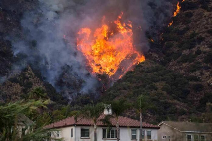
The Bike Fire was reported in Santa Clarita at 1:57 p.m. on October 11, 2026, near Camdria Estates Lane and Ravenhill Road. Within the first hours, incident commanders confronted fast spread in chaparral fuels and ordered evacuations for specific Santa Clarita zones as the fire pushed into the wildland–urban interface. CAL FIRE’s contemporaneous incident record documents a quick operational tempo: expanding evacuation areas as the rate of spread accelerated, followed by downgrades to advisories as lines held and behavior moderated later that evening. Multiple outlets tracked the expanding footprint in real time; estimates clustered around 200 acres during the midafternoon growth window, with new mandatory areas added shortly before 3 p.m. as a precaution against erratic runs.
Evacuations were not generic advisories; they were targeted to named public-safety zones. Reports cited orders for SCL-SULTUS, SCL-NADEU-A, SCL-SANDSOUTH-B, and SCL-MACMILLAN, with adjacent warnings instructing residents to prepare for immediate departure—a zoning approach that lets incident command meter risk by neighborhood and roadway egress capacity. Angeles National Forest officials characterized fire behavior as erratic during the period when orders and warnings shifted, consistent with gust-driven spotting and terrain-influenced runs that complicate perimeter holding.
Response mechanics: who did what, and why it matters
Wildland fire in Los Angeles County is a multi-agency discipline; the Bike Fire response reflected that. The Los Angeles County Fire Department led ground operations in concert with the Angeles National Forest, CAL FIRE, and the Los Angeles County Sheriff’s Department, which handled evacuation enforcement and road controls. County emergency management stood up civilian and animal sheltering: College of the Canyons served as a temporary evacuation point for residents while the Antelope Valley Fairgrounds received animals displaced from ranch and equestrian properties. This mobilization pattern—simultaneous structure protection, perimeter control, and evacuation support—is the doctrine that prevents a wind shift from becoming a mass-casualty event. The fact that orders were lifted around 8 p.m., after fireline progress and calmer behavior, indicates that the containment strategy and the evacuations achieved their narrow aim: separate civilians from the hazard while crews cut line and cooled hot edges.
Containment reporting framed public understanding throughout the afternoon. Figures around two-thirds containment appeared in official updates as crews tied lines to natural barriers and dozer cuts; but containment is a perimeter metric, not a safety verdict, which is why evacuation status can lag or lead containment percentages. Fire can still slop over a “contained” segment under gusts or ember cast, and unsecured interior heat can threaten if winds realign. Commanders were right to update containment and evacuation status on separate tracks.
Why the acreage kept changing—and why that’s normal
Readers saw 172, 200, 230, even 475 acres reported by different outlets during the same operational period. That discrepancy can look like error, but on an active incident it usually reflects different measurement moments and methods: quick visual estimates from division supervisors, polygon traces from aircraft, and later corrected perimeters from GIS. In the Bike Fire, the Los Angeles County Fire Department cited 230 acres midafternoon; CAL FIRE’s page referenced 200 acres with rapid spread; later mapping revised to roughly 172 acres; ABC7 carried a larger figure later in the cycle. The through-line is not contradiction but refinement: as aircraft map with better visibility or as slopovers are corralled into interior islands, the net burn area toggles. None of this undermines the evacuation rationale, which is built on forward spread potential, not a static area snapshot.
The practical implication for residents is straightforward: treat acreage as a directional indicator while you focus on your zone status and egress routes. Incident communications increasingly emphasize zone names and roadway closures for precisely this reason—operationally, your risk is a function of where the head and flanks can go in the next hour, not what the last perimeter encompassed.
Evacuation logic: decisions under uncertainty
Mandatory orders during the Bike Fire followed a familiar risk calculus: fuels and topography primed for fast runs, heat and wind supporting ember cast, and limited time windows on narrow canyon roads. Social science on wildfire behavior repeatedly shows that official orders are the single strongest driver of household movement, yet jargon and mixed messages can slow compliance at the margins. That’s why zone-specific, plainly worded directives (“leave now,” “warning—be ready”) matter more than colorful adjectives. The Bike Fire’s zone-based orders align with the evidence: clear cues prompt faster, safer departures, especially before visibility drops or aircraft are grounded by smoke later in the day.
Two details shaped public perception here. First, no confirmed injuries or structural losses appeared in early reporting; second, orders were downgraded within hours. For some, that combination invites Monday-morning quarterbacking. But wildfire evacuation is an ex ante safety measure judged against worst-plausible spread, not a guarantee of visible harm. Research on evacuation behavior and risk perception underscores this gap between what officials must act on and what residents later see; it’s a recurring feature of high-tempo incidents, not a failure of judgment.
FAST MOVING CALIFORNIA WILDFIRE FORCES EVACUATIONS
A rapidly spreading wildfire is threatening communities in Santa Clarita, California, forcing residents to evacuate as flames sweep through dry vegetation.
The fire broke out Sunday afternoon near Camdria Estates Lane and… pic.twitter.com/9n66Ee2fsb
— Michael Bradbury (@MrMBB333) October 12, 2026
What to watch going forward: transparency and after-action clarity
The operational backbone of the Bike Fire was sound: early orders, multi-agency coordination, people-and-animal sheltering, and independent tracks for containment and reentry. The improvement area—common across Western wildfire response—is post-incident clarity. When agencies publish a concise after-action brief that shows the chronological map perimeters, the criteria for each zone’s status change, and the timing of resource surges, residents can reconcile the day’s shifting numbers with the logic of the decisions made. That prevents acreage chatter from eclipsing the core safety objective and trains the public to track the variables that matter most during the next red-flag afternoon.
Sources:
nypost.com, fire.ca.gov, dailynews.com, cbsnews.com, rollingout.com, yahoo.com, ground.news