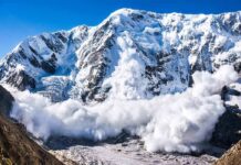


When a Himalayan glacial lake drains upstream of a border, it is not just a local disaster; it is a stress test of transboundary infrastructure, emergency coordination, and the political will to share risk in a rapidly warming mountain range.
At a Glance
- A sudden flood along the Bhote Koshi/Trishuli corridor killed at least eight people in Nepal and caused major casualties in Tibet, with rescues and searches continuing.
- The surge destroyed the Nepal–China “Friendship” (Miteri) Bridge and damaged roads, customs facilities, vehicles, and energy infrastructure that anchor cross-border trade.
- Evidence from officials and early technical assessments indicates an upstream glacial-lake drainage on the Tibetan side triggered the flood wave.
- This corridor is a known transboundary hazard hotspot; modeling and field studies show growing exposure of bridges, dry ports, and hydropower to outburst floods.
What Happened: A Cross-Border Flood With Human and Infrastructure Losses
Authorities in Nepal confirmed multiple fatalities and a large rescue operation after a powerful flood struck Rasuwa district along the Nepal–China frontier. Police and army officials reported at least eight bodies recovered and dozens rescued as teams worked along the Bhote Koshi River, which forms the border before continuing downstream as the Trishuli in Nepal. Chinese state media, speaking to conditions on the Tibet side of the crossing, described “major casualties” from a mudslide at a key trade hub, underscoring that this was a bilateral disaster, not a localized cloudburst. Amid the torrent, the Miteri/“Friendship” Bridge—the principal road link at Rasuwagadhi–Gyirong—was swept away, together with stacks of vehicles at the adjacent dry port and critical sections of the Syabrubesi–Rasuwagadhi road.
Early tallies are necessarily fluid in fast-evolving mountain emergencies, but the operational picture is consistent: helicopters ferried search-and-rescue teams into narrow valleys, district administrators warned of additional losses, and customs and immigration facilities closest to the river were heavily damaged or inundated. Nepal’s security services also reported personnel missing from a border outpost, illustrating how quickly a surge can overrun even trained responders positioned near the channel.
Mechanism: A Glacial-Lake Outburst Routed Through a Trade Corridor
While monsoon cloudbursts can trigger debris floods in the Himalaya, multiple sources—officials, disaster networks, and climate-focused institutions—point to an upstream lake drainage on the Tibetan side as the initiator in this event. In 2025, a similar surge that destroyed the same bridge was traced by a regional climate body to the rapid drainage of a supraglacial lake in Tibet; that diagnostic pattern matches the reports from this catastrophe: a sudden, sediment-laden wave moving down the Lende/Poiqu–Bhote Koshi–Trishuli system into Nepal. These outbursts, known as GLOFs (glacial lake outburst floods), occur when a moraine or ice dam fails or when a rock/ice avalanche displaces lake water over a natural dam. The resulting flood entrains boulders and fine sediments, amplifying its erosive power and, crucially for infrastructure, delivering a high-density slurry that can scour bridge abutments and sweep parked cargo in a single pass.
Field surveys and remote-sensing work along the China–Nepal border near Mt. Xixabangma have already documented two exceptional GLOFs in 2025 with severe transboundary impacts; hydrodynamic modeling shows that multiple lakes in this border zone can produce flood peaks far larger than those anticipated by gradual breach scenarios, with impacts propagating across dozens of kilometers of road, more than a hundred bridges, dry ports, and thousands of buildings on both sides. That is not an abstract warning. It is the exact profile of what failed here: a high-value crossing with customs yards, energy assets, and market towns concentrated in a narrow valley flanked by erosion-prone slopes.
Why This Border Is So Exposed: History, Infrastructure, and Warming
The Rasuwagadhi–Gyirong corridor has been deliberately built up over the past two decades as a secondary gateway to China after Kodari–Zhangmu was crippled by the 2015 earthquakes and subsequent landslides. New roads, yards, and power lines hug the river to minimize tunneling and to keep grades truck-manageable; the tradeoff is obvious when a surge arrives. Nepal has recorded at least two dozen GLOF events nationally over the modern observational era, including several that originated in Tibet and propagated into Nepal’s river network. A curated database for High Mountain Asia counts 190 potentially transboundary GLOFs historically, but fewer than ten with confirmed cross-border impacts—Rasuwagadhi–Gyirong is one of those rare, consequential flashpoints.
As warming thins ice and expands moraine-dammed lakes, the number of lakes posing a transboundary threat along the China–Nepal border is projected to increase, and the worst-case discharges at the frontier could exceed prior experience by an order of magnitude if destabilized by large avalanches into the lakes. In parallel, Nepal’s domestic strategy to electrify transport and export surplus hydroelectricity depends on river-corridor infrastructure—penstocks, switchyards, access roads—that sits in the path of these outburst waves. Analyses of the 2025 event linked GLOF losses directly to disrupted energy and trade; that causal chain is visible again in the latest damage to hydropower and logistics nodes.
Response and Coordination: What Worked and What Must Improve
On the Nepal side, multi-agency deployment—army, armed police, and civil police—moved quickly with air support to extract survivors and ferry medical teams into cut-off settlements. Disaster networks tallied infrastructure hits across transport and power, giving responders a triage map for reopening access and stabilizing the grid. Local administrators issued evacuation alerts as the flood wave moved downstream and as aftershocks—secondary slides and bank failures—threatened additional damage. These are the layers we expect to see in a competent incident response in difficult terrain: vertical lift, inter-agency command, and real-time warnings into river communities.
But GLOFs are upstream-driven hazards. The most valuable seconds in a transboundary outburst are upstream minutes—automated gauging, satellite-based lake monitoring, and formalized alert-sharing across the border. After the 2025 destruction of the bridge, Nepal and China agreed to cooperate on glacial-lake risk reduction and warning protocols; the current disaster is the first hard test of whether those agreements are maturing into operational practice—pre-positioned data, pre-cleared communications channels, and synchronized drills that translate warnings into evacuations at river speed. The technical underpinnings exist: rapidly updated remote sensing, hydrodynamic nowcasting, and siren/SMS cascades keyed to trigger levels. What determines outcomes is whether upstream detections are treated as shared risk intelligence—dispatched across languages and bureaucracies without delay.
What This Means Going Forward: Designing for the Next Outburst
This corridor will flood again. The question is whether the next wave yields a similar death toll and multicenter infrastructure failure. Three design principles emerge from the evidence. First, treat the Rasuwagadhi–Gyirong crossing as a GLOF corridor, not a generic mountain pass. That means bridge siting and abutment design for high-velocity, debris-rich slurries; sacrificial road segments engineered to fail safely; and dry-port layouts that keep high-value assets out of predictable inundation zones identified by multi-scenario modeling.
Second, operationalize binational early warning. Standardize telemetry and threat levels so that a lake-drainage detection upstream pushes an automatic, authenticated alert downstream within minutes; cross-train district officials on both sides on shared playbooks so that evacuation and asset protection measures trigger without a diplomatic dance. Third, align energy and trade planning to the hazard map. New hydropower intakes, switchyards, and logistics parks should be permitted only with demonstrated performance under modeled outburst loads and debris impacts—disruption to Nepal’s energy transition and cross-border commerce is too costly to treat as residual risk.
None of this eliminates hazard in a steep, young mountain belt where water and rock are still carving the channels. But the record now stretches across events and years, not headlines and days. The science is clear on mechanism, exposure, and feasible countermeasures; the latest flood only clarifies the price of delay.
BREAKING: New footage shows absolutely horrifying scenes along the China-Nepal border amid devastating flash floods, hundreds missing, many feared dead pic.twitter.com/hwXTz8IzjP
— Insider Paper (@TheInsiderPaper) August 26, 2026
Bottom Line
A deadly, debris-charged surge traveled from Tibetan headwaters into Nepal’s trade artery, killing people on both sides of the border and tearing out the very bridge meant to knit the economies together. Investigations from the 2025 analog and current disaster reporting point to glacial-lake drainage upstream as the trigger, a risk not just foreseen but quantified in the literature. The remedy is not a mystery: build for the flow we know can arrive, wire the corridor for shared warning, and move critical assets out of the channel’s reach. The Himalaya will keep testing us; our designs and institutions must be ready.
Sources:
insiderpaper.com, myrepublica.nagariknetwork.com, tribuneindia.com, dpnet.org.np, aljazeera.com, ianslive.in, newindianexpress.com, nytimes.com, bbc.com, climatechangenews.com, stimson.org, pubmed.ncbi.nlm.nih.gov, pmc.ncbi.nlm.nih.gov, dialogue.earth, essd.copernicus.org, mdpi.com